توضیحات
چکیده
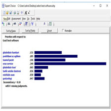
میراث فرهنگی به عنوان یک پدیده منحصر له فرد، غیرقابل جایگزینی و در میان نسلها ازارزش و احترام برخوردار است. این پدیده یک پدیده مکان مبنا بوده و شامل مجموعه ای از اطلاعات مکانی و توصیفی می باشد. داده های مکانی نیز بعنوان یک شاخص و زیرساخت در جهت توسعه کشور اهمیت دارد. برای نیل به اهداف مختلف داده های مکانی باید موجود باشند. یکی از مهمترین مسایل امروزی دسترسی به داده های مکانی می باشد. ارگان ها وسازمان های زیادی وجود دارند که بر اساس نیاز خود داده های مکانی جمع آوری و تهیه کرده اند. در نتیجه تولید دوباره این داده ها کار وقت گیر و هزینه بر می باشد. بسیاری از داده های تولید شده و حتی بهنگام شده در دسترس کاربران قرار ندارد. برای دسترسی به داده های مکانی تمامی کاربران باید از وجود داده های مکانی مطلع باشند. با طراحی و پیاده سازی یک ژیوپورتال می توان به وجود سرویس های مکانی که بر اساس استانداردهای موجود ساخته شده اند آگاه بود و به آنها دسترسی پیدا کرد. برای طراحی و پیاده سازی ژیوپورتال از نرم افزارهای متن باز می توان استفاده کرد. تکنیک های زیادی برای انتخاب یک نرم افزار مناسب وجود دارد. در این مقاله پارامترها و معیارهایمختلفی در انتخاب بهترین نرم افزار برای پیاده سازی یک ژیوپورتال در نظر گرفته شده است. جهت انتخاب نرم افزار مناسب از تلفیق دو روش AHP و SWOT استفاده شده است. ابتدا معیارها با استفاده از روش AHP وزن دهی شدند. همچنین با مشخص کردن قوت ها، ضعف ها، فرصت ها و تهدیدها از روش SWOT برای انتخاب نرم افزار مناسب استفاده شده است.
ABSTRACT
Cultural heritage as an individual phenomenon is indispensable and generous and respectful among generations. This phenomenon is a base location phenomenon and includes a set of spatial and descriptive information. Spatial data is also important as an indicator and infrastructure for the development of the country. To achieve different goals, spatial data must be available. One of the most important issues today is access to spatial data. There are many organizations and organizations that collect and supply spatial data based on their needs. As a result, the production of these data is time consuming and costly. Many of the data produced and even up-to-date are not available to users. To access spatial data, all users must be aware of spatial data. By designing and implementing a gioportal, you can be aware of and access to the location services that are built on existing standards. You can use open source software to design and implement GeoPortal. There are many techniques to choose from. In this article, there are various parameters and criteria for choosing the best software for the implementation of a gioportal. AHP and SWOT have been used to select the appropriate software. At first, the criteria were weighted using the AHP method. Also, by identifying strengths, weaknesses, opportunities and threats, the SWOT approach has been used to select the appropriate software.
Year: ۲۰۱۸
Publisher : The 2nd National Conference on the Documentation of Natural and Cultural Heritage
By : Zahra Mousavi, Saeed Behzadi
File Information: English Language/ 12 Page / size: 1.10 MB
Only site members can download free of charge after registering and adding to the cart
سال : ۱۳۹۷
ناشر : دومین همایش ملی مستندنگاری میراث طبیعی و فرهنگی
کاری از : زهرا موسوی ،سعید بهزادی
اطلاعات فایل : زبان فارسی / 12 صفحه / حجم : MB 1.10
![Total quality management, corporate social responsibility[taliem.ir]](https://taliem.ir/wp-content/uploads/Total-quality-management-corporate-social-responsibilitytaliem.ir_.jpg)

![Management Forecasts, Idiosyncratic Risk, and the Information Environment[taliem.ir]](https://taliem.ir/wp-content/uploads/Management-Forecasts-Idiosyncratic-Risk-and-the-Information-Environmenttaliem.ir_-1.jpg)
![Design and development of logistics workflow systems for demand[taliem.ir]](https://taliem.ir/wp-content/uploads/Design-and-development-of-logistics-workflow-systems-for-demandtaliem.ir_.jpg)


نقد و بررسیها
هنوز بررسیای ثبت نشده است.