توضیحات
چکیده
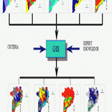
مديريت پارکينگ يکي از مهمترين ابزار در مديريت شهری است . سطوح مختلف امکانات پارکينگ میتواند بر کارايي ترافيک و کيفيت زندگي شهري تأثير بگذارد. تصمیمات نادرست و مديريت غير استاندارد موجب تأثير نامطلوب بر سيستم ترافيکي شهري ٬ صدمه و تخريب محيط زيست ٬ افزايش در هزینههای ساخت و مانع از پيشر فت اقتصادي میشود . بعد از گذشت چندين ده ه و افز ا يش اتومبيل و نبود فضاي کافي براي پارک و در نهايت هزينه زياد زياد ساختن امکانات پارکينگ ٬ ارزيابي دقيق براي مديريت و مکانيابي پارکينگ را ضروري ساخت . اين مقاله مديريت و امکان سنجي مکان مناسب پارکی نگ در شهرها ر ا٬ بادر نظر گرفتن عرضه و تقاضاي پارک و عوامل مؤثر بر آنها بررسي میکند . در اينجا دو هدف را دنبال میکنیم : ۱- استفاده از تکنولوژي سيستم اطلاعات جغرافيايي ( GIS ) در حل مشکلات پارکينگ شهرها ۲- ايجاد استراتژي براي گسترش سيستم مديريت پارکينگ ٬ جهت فراهم کردن راه حلهاي دائمي براي مشکل پارکينگ . اين تحقيق بر آناليز جغرافيايي در محيط GIS استوار است . همچنين ارزيابي الگوهاي دسترسي در منطقه مطالعاتي بر اساس روشهاي بر هم نهي بکمک تکنولوژي GIS همراه با ملاحظات تقاضاي پارک و کاربري چند گانه زمين ٬ بررسي میشود .
ABSTRACT
Parking management is one of the most important tools in urban management. Different levels of parking facilities can affect traffic efficiency and quality of urban life. Incorrect decisions and substandard management will have an adverse effect on the urban traffic system – damage and destruction of the environment, increase in construction costs and impede economic development. After decades of adding more cars and insufficient parking space and ultimately increasing the cost of parking facilities, it required a careful assessment of parking management and location. This article examines the management and feasibility of proper parking in cities considering the supply and demand of the park and the factors affecting it. Here are two goals: – Using GIS technology to solve city parking problems; – Developing a strategy to develop a parking management system; To provide permanent solutions to the parking problem. This research is based on geographic analysis in GIS environment. Evaluation of access patterns in the study area is also evaluated using GIS technology interoperability methods with considerations of park demand and multiple land use.
Year: ۲۰۱۶
Source : ۰
By : 0
File Information: persian Language/ 35 Page / size: 4.30 MB
سال : ۱۳۹۵
منبع : ۰
کاری از : 0
اطلاعات فایل : زبان فارسی / 35 صفحه / حجم : MB 4.30


![Competitiveness, Entrepreneurship[taliem.ir]](http://taliem.ir/wp-content/uploads/Competitiveness-Entrepreneurshiptaliem.ir_.jpg)


نقد و بررسیها
هنوز بررسیای ثبت نشده است.