توضیحات
چکیده
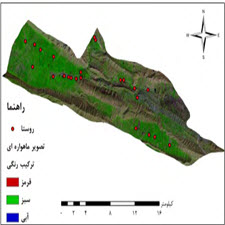
مخاطرات محیطی معضلی است که همواره گریبانگیر کشور ایران را گرفته است. زمانی که این مخاطره بصورت گسترده در سطح کشور اتفاق میافتد و نیاز به آماری سریع و تقریبا دقیق است، سنجش از دور میتواند ابزاری کارا باشد. با این تفاسیر با استفاده ازتصاویر ماهواره ای اقدام به برآورد خسارت سیل به اراضی کشاورزی و روستاهای دهستان کونانی شهرستان کوهدشت لرستان شد. در این مطالعه با استفاده از تصاویر اپتیک ماهواره سنتیل- 2 ، نقشه مناطق زیرکشت استخراج کردید و با استفاده از تصاویر راداری ماهواره سنتینل- 1 ، پهنه ها سیل گرفته مشخص شد. بر اساس نتایج، در حدود 10000 هکتار از اراضی منطقه مورد مطالعه زیرکشت بوده و بیش از 4900 هکتار از منطقه تحت تاثیر سیلاب بوده است که از این مقدار حدود 4700 هکتار از اراضی کشاورزی و 16 روستا از سیل آسیب دیده اند، که با یک برآورد ساده میتوان گفت فقط اراضی کشاورزی بیش از 14 میلیارد تومن خسارت دیده اند.
مقدمه
بلایای طبیعی در سراسر جهان تأثیر فوق العاده ای در محیط منطقه ای و جهانی از لحاظ اقتصادی دارند. از این لحاظ استراتژی بین المللی کاهش بلایا (ISDR) با هدف کاهش آسیب پذیری و خطردر سراسر جهان مطرح شد (کاراجیوزی و همکاران 2011). از سال 1997تا سال 1998حدود 390000نفر در جهان در جان خود را از دست دادند که از این میزان 58درصد مربوط به سیلاب بوده است. هرگاه شدت بارندگی از ظرفیت نفوذ آب به داخل خاک بیشتر باشد بخشی از آب حاصله از بارندگی پس از پر کردن گودی ها و حفره ها سطح زمین در امتداد شیب جریان مییابد به این بخش از بارندگی رواناب سطحی گفته میشود (علیزاده، .)1388اهمیت مطالعات سیل و خسارت سالانه ناشی از سیل باعث شده تا لزوم توجه به مطالعات آن در دستور کار اتحادیه اروپا قرار گیرد و کشورهای عضو ملزم به تهیه نقشه سیل برای کشور خود شوند (ثقفی و رضایی مقدم 1391) .سیلاب مخاطرهای است که از دیرباز تا کنون جوامع بشری با آن روبهرو است و خسارات اقتصادی و اجتماعی چندی به همراه دارد.
ABSTRACT
Environmental hazards are a problem that has always plagued Iran. Remote sensing can be an effective tool when this risk is widespread across the country and requires rapid and nearly accurate statistics. These interpretations were used to estimate flood damage to agricultural lands and villages of Konani village in Kuhdasht Lorestan province using satellite imagery. In this study, we extracted the map of cultivated areas using Sentinel-2 satellite optical images and flooded areas were identified using Sentinel-1 satellite radar images. According to the results, about 10,000 hectares of the study area were cultivated and more than 4900 hectares were affected by floods, of which about 4700 hectares of agricultural lands and 16 villages were affected by floods, with one estimate Simply put, agricultural lands alone have damaged more than 14 billion tomans.
INTRODUCTION
Natural disasters around the world have a tremendous impact on the regional and global environment economically. In this regard, the International Disaster Reduction Strategy (ISDR) was introduced with the aim of reducing vulnerability and risk worldwide (Karajozi et al. 2011). Between 1997 and 1998, about 390,000 people died in the world, 58% of which were floods. When the intensity of rainfall exceeds the capacity of infiltration into the soil, part of the water resulting from rainfall after filling the holes and holes on the ground flows along the slope, this part of the rainfall is called surface runoff (Alizadeh, 2009). The annual floods and damage caused by floods have made it necessary for the European Union to put its studies on the agenda and to oblige member states to prepare flood maps for their country (Saghafi and Rezaei Moghadam 2012). Human societies are facing it, with some economic and social damage.
Year: ۲۰۱۹
Publisher : 14th Congress of Iranian Geographical Society
By : Mohammad Maleki, Amin Mosali Zadeh
File Information: English Language/ 7 Page / size: 328 KB
Only site members can download free of charge after registering and adding to the cart
سال : ۱۳۹۸
ناشر : چهاردهمین کنگره انجمن جغرافیایی ایران
کاری از : محمد ملکی, امین مستعلی زاده
اطلاعات فایل : زبان فارسی / 7 صفحه / حجم : KB 328


نقد و بررسیها
هنوز بررسیای ثبت نشده است.